
Explore Langtang Valley Nepal with routes, permits, costs, seasons, packing tips, safety advice and a complete itinerary.
Complete Travel Guide to Langtang Valley, Nepal
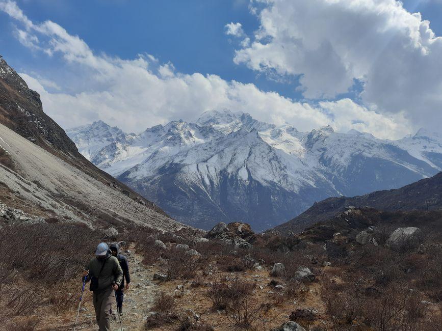
Langtang Valley Nepal feels wonderfully remote even though it begins only a long drive north of Kathmandu. Deep forests give way to terraced Tamang villages, glacial rivers and immense Himalayan peaks. At Kyanjin Gompa, the valley opens beneath Langtang Lirung, where crisp mornings, Buddhist prayer flags and welcoming teahouses create one of Nepal’s most rewarding trekking atmospheres.
This Complete Travel Guide to Langtang Valley covers the best seasons, a practical itinerary, permits, costs, accommodation, packing, safety and cultural etiquette. The route is less crowded than Everest and Annapurna, yet it offers dramatic scenery, manageable trekking days and a meaningful opportunity to support communities that have rebuilt after the devastating 2015 earthquake.
Langtang Valley at a glance
| Detail | Information |
|---|---|
| Location | Rasuwa District, Bagmati Province, northern Nepal |
| Nearest road head | Syabrubesi, approximately 1,460 metres |
| Typical duration | 7 to 10 days from Kathmandu |
| Approximate trekking distance | 65 to 80 kilometres, depending on side trips |
| Highest common overnight stop | Kyanjin Gompa, approximately 3,830 metres |
| Popular viewpoints | Kyanjin Ri at 4,773 metres and Tserko Ri at 4,984 metres |
| Main peak views | Langtang Lirung, Dorje Lakpa, Yala Peak and surrounding glaciers |
| Difficulty | Moderate; no technical climbing is required |
| Accommodation | Teahouses and small local lodges |
| Best seasons | Late September to November and March to May |
| Required permits | Langtang National Park entry permit and TIMS card |
Why visit Langtang Valley?
Spectacular scenery without an extreme trek
The Langtang route delivers a remarkable change in landscape. Subtropical forest around the lower trail gradually becomes oak, rhododendron and bamboo woodland. Above the tree line, the valley reveals moraines, icy streams and towering peaks. Langtang Lirung rises to 7,227 metres and dominates the horizon around Kyanjin.
Although the trail includes steep climbs and descents, it does not require mountaineering experience. A reasonably fit walker can enjoy the valley with a steady pace and proper acclimatisation.
Rich Tamang culture
Langtang lies close to the Tibetan border and has strong Tamang and Tibetan Buddhist influences. Prayer flags, mani walls, chortens and small monasteries appear throughout the route. Villages such as Langtang, Mundu and Kyanjin provide opportunities to learn about local traditions, architecture and food. Always ask before photographing people or religious ceremonies.
A meaningful community-based visit
The 2015 earthquake triggered a massive ice, rock and snow avalanche that destroyed much of the original Langtang village and caused profound loss. The community has since rebuilt its lodges and trails. Visiting responsibly, employing local guides and staying in locally owned teahouses directly contributes to the region’s continuing recovery.
Easier to combine with other routes
The classic Langtang trek can be extended towards Langshisa Kharka, connected with Gosaikunda and Helambu over the Lauribina La, or combined with the culturally focused Tamang Heritage Trail. These variations require additional time and careful planning, particularly in winter or immediately after snowfall.
Best time to visit Langtang Valley
Autumn: late September to November
Autumn is generally the most popular season. Stable weather, clear mountain views and comfortable daytime temperatures make it ideal for trekking. Nights become cold at higher elevations as November advances. Lodges fill quickly during October, so booking through a guide or agency is wise.
Spring: March to May
Spring brings warmer weather, green forests and rhododendron blossoms. The air can be hazier than in autumn, but the landscape is colourful and wildlife is active. Afternoon clouds may obscure peaks, making early starts valuable.
Winter: December to February
Winter offers clear skies and fewer trekkers, but nights around Kyanjin can fall well below freezing. Snow may block higher trails or viewpoints. Experienced trekkers can enjoy the solitude, but extra insulation and flexible plans are essential.
Monsoon: June to mid-September
The monsoon produces lush vegetation but also clouds, rain, leeches and a higher risk of landslides on the road to Syabrubesi. Mountain views are unreliable. Trekking is still possible during drier breaks, but travellers should expect delays and slippery paths.
Recommended 9-day Langtang Valley itinerary
This itinerary balances progress with acclimatisation. Walking times vary with fitness, weather, landslides and the exact teahouse selected.
Day 1: Kathmandu to Syabrubesi
The journey normally takes 7 to 9 hours by shared bus or private jeep. The road follows the Trishuli River before climbing through hilly terrain. Landslides can extend travel time. Spend the afternoon checking permits, organising gear and resting rather than undertaking strenuous sightseeing.
Day 2: Syabrubesi to Bamboo or Rimche
The trail crosses the Langtang Khola and passes through forest with opportunities to see birds and langur monkeys. Bamboo, at about 1,960 metres, makes a moderate first day. Fit trekkers may continue to Rimche, around 2,470 metres, reducing the following day’s walk.
Day 3: Bamboo or Rimche to Lama Hotel
The path climbs and descends through dense woodland, with suspension bridges and views across the river valley. Lama Hotel is a settlement of teahouses near the river at roughly 2,310 to 2,380 metres. Those who stopped at Bamboo may choose Rimche as an intermediate overnight stop.
Day 4: Lama Hotel to Langtang village
After climbing past Ghodatabela, the forest begins to open and the first broad mountain views appear. The trail follows the river into the main valley and passes rebuilt settlements before reaching Langtang village at approximately 3,436 metres. This is a good place to visit the memorial and learn respectfully about the 2015 disaster.
Day 5: Langtang village to Kyanjin Gompa
The walk is relatively short but continues upward to Kyanjin Gompa, usually placed at about 3,830 metres. Passing through Mundu and traditional stone walls, the valley becomes wider and more alpine. Explore the monastery area, a local cheese operation and the surrounding moraines, but avoid overexertion while acclimatising.
Day 6: Acclimatisation and Kyanjin Ri or Tserko Ri
An acclimatisation day is strongly recommended. Kyanjin Ri generally requires 3 to 5 hours round trip and provides close views of Langtang Lirung and the Kyanjin glacier. Tserko Ri is longer and steeper, often taking 5 to 8 hours, but offers one of the finest panoramas in the region.
Choose the lower viewpoint if you have a headache, nausea, unusual fatigue or any other symptoms of altitude sickness. Never climb higher to try to overcome symptoms.
Day 7: Kyanjin Gompa to Lama Hotel or Ghodatabela
Retrace the valley while enjoying the scenery from a different perspective. Descending to Lama Hotel creates a comfortable stopping point. Very fit walkers may continue to Ghodatabela, although this makes a long day after the previous hike.
Day 8: Lama Hotel to Syabrubesi
The final trekking day passes back through forested terrain and riverside settlements. Expect repeated descents to the bridge near Lama Hotel followed by the long drop to Syabrubesi. Use the evening to confirm transport and count cash for the next day.
Day 9: Syabrubesi to Kathmandu
The return drive usually takes 7 to 9 hours. Roadworks, traffic and landslides can cause delays, so avoid scheduling an international flight on the same day. A buffer day is especially important if travelling in the monsoon or winter.
A fit traveller may complete the classic route in seven trekking days, while a relaxed 10-day plan allows extra nights in Langtang and Kyanjin. The additional rest improves both enjoyment and acclimatisation.
How difficult is the Langtang Valley trek?
Langtang is considered a moderate Nepal trek. There is no technical climbing, but expect stone steps, rocky paths, suspension bridges and sustained uphill sections. Typical walking days last 4 to 7 hours. The ascent from Lama Hotel to Langtang village is significant, and the viewpoint climbs above Kyanjin are strenuous.
Good cardiovascular fitness helps, but pacing matters more than speed. Practise hiking with a daypack, use poles if your knees are sensitive and break in footwear before arrival. A guide or porter can carry heavier luggage, allowing you to walk with water, layers and personal items only.
Permits and current trekking regulations
Most foreign visitors need two documents:
- Langtang National Park entry permit: This supports conservation and local management. Foreign nationals should budget around NPR 3,000 plus applicable tax. Rates differ for SAARC nationals and children.
- TIMS card: The Trekker’s Information Management System card costs less for trekkers travelling through an agency than for independent trekkers. Current planning rates are approximately NPR 1,000 to NPR 2,000.
Permit fees and procedures can change. Obtain documents through the Nepal Tourism Board, an authorised office or a registered trekking agency, and carry your passport, permit copies and passport photographs. Checkpoints may request to see them.
Nepal officially restricts unguided solo trekking on the Langtang route and several other designated trekking areas. Use a licensed guide or a registered trekking company and confirm the latest rules before departure. Guides also assist with language, navigation, teahouse arrangements and emergency decisions.
Getting to and from Langtang Valley
Most treks begin in Syabrubesi. Shared buses and tourist vehicles generally leave Kathmandu early in the morning. A private jeep costs more but can provide a more comfortable and flexible journey. The road is paved for sections but remains vulnerable to construction, congestion and landslides.
There is no airport in Langtang Valley. Helicopters are used for emergencies rather than routine transport. On return, arrange a jeep in Syabrubesi or take the scheduled bus to Kathmandu. Keep at least one spare day in your overall Nepal itinerary for road delays.
Langtang Valley trek cost and budget
Costs depend on group size, guiding, food choices and comfort preferences. Useful planning ranges include:
- Park permit and TIMS: Approximately NPR 4,000 to NPR 6,000 per foreign adult, including applicable charges.
- Shared transport: Often around USD 10 to 25 each way.
- Private jeep: Commonly USD 120 to 200 or more per vehicle each way, depending on season and negotiation.
- Independent teahouse trekking: Roughly USD 25 to 45 per day for a room, three meals, drinks, charging and showers.
- Guided trek: Frequently USD 70 to 130 per person per day on an organised package, depending on group size and inclusions.
Rooms may be inexpensive when meals are purchased at the same lodge, but prices rise with altitude because supplies are carried by porters or animals. Carry sufficient Nepali rupees from Kathmandu. ATMs in Syabrubesi should not be relied upon, and cards are rarely accepted on the trail. Confirm whether a guide’s quoted price includes permits, meals, accommodation, insurance, porter support and transport.
Food and accommodation on the trail
Teahouses normally provide simple twin rooms with a mattress, pillow and blanket. Bring a sleeping bag because blankets may be unavailable, damp or insufficient in cold weather. Bathrooms are usually shared, and hot showers often cost extra. Electricity may come from solar or micro-hydro systems, so charging a phone or camera can carry a fee.
Menus become shorter at higher elevations. Common dishes include dal bhat, fried rice, noodles, potatoes, porridge, pancakes, momos, soup and Tibetan bread. Dal bhat is filling and often the best-value meal. Meat must be transported uphill, so vegetarian food is generally a safer and more sustainable choice above the lower villages.
Drink only treated water. Use purification tablets, a filter or UV treatment, or buy boiled water when available. Avoid single-use plastic bottles by carrying refillable bottles and bringing treatment supplies.
What to pack for Langtang Valley
Pack light enough to walk comfortably, but prepare for conditions ranging from warm forest trails to freezing nights.
Essential clothing
- Moisture-wicking T-shirts and trekking shirts
- Warm fleece or synthetic insulated layer
- Down or synthetic jacket
- Waterproof and windproof shell jacket and trousers
- Trekking trousers plus thermal leggings
- Warm hat, sun hat and gloves
- Several trekking socks and underwear
- Comfortable clothes for evenings
Footwear and equipment
- Broken-in hiking boots or trail shoes with strong grip
- Camp shoes or sandals
- Trekking poles
- Headlamp with spare batteries
- Sleeping bag rated for below-freezing conditions
- Daypack of 25 to 35 litres
- Duffel bag if using a porter
- Reusable water bottles or hydration system holding at least 2 litres
- Water purification tablets, filter or UV purifier
Personal items
- Passport, permits and several passport photographs
- Travel insurance documents
- Sunscreen, lip balm and UV-protection sunglasses
- Basic first-aid kit and personal medication
- Hand sanitiser, toilet paper and biodegradable soap
- Quick-dry towel and wet wipes
- Power bank and charging cables
- Snacks such as nuts or energy bars
- Dry bags or waterproof packing sacks
Normal autumn or spring trekking does not require mountaineering equipment. Winter travellers may need additional insulation and traction, but snow conditions should be assessed locally with a guide.
Health, altitude and safety advice
Prevent altitude sickness
The classic route rises from Syabrubesi at 1,460 metres to Kyanjin Gompa at about 3,830 metres. The scheduled nights provide useful acclimatisation, but altitude sickness can still occur. Walk slowly, drink according to thirst, eat well and avoid alcohol or sleeping tablets at elevation.
Watch for headache, loss of appetite, nausea, dizziness, unusual tiredness and disturbed sleep. Do not ascend if symptoms persist. Worsening headache, repeated vomiting, confusion, loss of coordination or breathlessness at rest can indicate a serious condition requiring immediate descent and medical help.
A clinician can advise whether acetazolamide is appropriate, but medication does not replace a careful ascent plan.
Prepare for changing conditions
Weather can shift quickly, and landslides may affect both roads and trails. Start early, check forecasts and follow local advice. Do not cross swollen rivers or enter unstable slopes merely to maintain an itinerary.
Earthquakes are a known hazard in Nepal. Ask your lodge about exits and keep shoes, a headlamp and warm clothing accessible at night.
Carry suitable insurance
Choose travel insurance that explicitly covers trekking to at least 5,000 metres, emergency helicopter evacuation, hospital treatment and trip disruption. Keep the policy number and emergency contact available offline.
Hygiene and food safety
Wash or sanitise hands before meals. Freshly cooked hot food is preferable to food that has sat out for a long time. Treat all untreated water, including water from taps and streams.
Wildlife and natural heritage
Langtang National Park was established in 1976 and covers about 1,710 square kilometres. Its elevation range supports oak and rhododendron forests, bamboo, alpine meadows, glaciers and high-altitude wilderness. The park is habitat for the red panda, Himalayan black bear, snow leopard, musk deer, langur monkeys and numerous pheasants and raptors.
Most animals are secretive and should not be expected as guaranteed sightings. Keep noise low, never feed wildlife, store food securely and remain on marked trails. Do not remove plants, minerals or cultural stones.
Culture and responsible etiquette
Many residents are Tamang, with language, dress and religious traditions influenced by centuries of Himalayan exchange. Greet people politely, learn a few Nepali words and support local businesses. Ask permission before entering private areas or taking close photographs.
Walk respectfully around chortens and mani walls, generally following the local clockwise direction. Do not sit on religious structures, move stones or touch offerings. Dress modestly in villages and remove shoes when entering a monastery if instructed.
The memory of the 2015 disaster remains deeply personal. Visit memorials quietly and avoid intrusive questions. If you wish to help, contribute through established community organisations rather than giving sweets, pens or money directly to children.
Connectivity, money and facilities
Mobile coverage is available in parts of the valley but can be weak or absent in forests and narrow sections. NTC service is often more reliable than other networks, although no connection should be guaranteed. Some lodges offer paid Wi-Fi.
Electricity is less dependable than in Kathmandu, particularly in cloudy weather. Carry a power bank and switch devices to low-power mode. Bring cash in small NPR denominations for meals, showers, charging, tips and emergencies.
Toilets and bathing facilities become more basic with altitude. Lower lodges may offer attached bathrooms, while higher accommodation usually has shared facilities. Confirm expectations with your guide rather than assuming hotel-style amenities.
Useful extensions and side trips
Langshisa Kharka
A trail branches beyond Langtang village toward Langshisa Kharka, at roughly 4,300 metres. The scenery is wild and the lodges more basic. Add one or two days and verify trail and weather conditions locally.
Gosaikunda and Helambu
Experienced trekkers can cross the Lauribina La, approximately 4,610 metres, from the Langtang region toward Gosaikunda and Helambu. The combined journey commonly requires 12 to 15 days or more. Snow, altitude and weather make this unsuitable for a rushed itinerary.
Tamang Heritage Trail
The Tamang Heritage Trail explores villages north and west of the main Langtang approach. It is especially rewarding for travellers interested in culture, traditional architecture and community tourism. It can sometimes be linked with the classic valley route.
Langtang Valley travel tips
- Book autumn accommodation early and retain flexibility for road delays.
- Spend an extra night in Kyanjin rather than rushing the viewpoint climb.
- Eat dal bhat for a filling, good-value meal.
- Keep passport, permits, insurance and cash in a waterproof document pouch.
- Carry snacks because villages are spaced apart.
- Use a licensed guide and treat porters fairly, including agreed wages, reasonable loads, proper clothing, accommodation and insurance.
- Refill bottles instead of buying disposable plastic ones.
- Pack out batteries, wrappers and other waste that cannot be managed locally.
- Avoid scheduling a flight on the day you drive back to Kathmandu.
- Respect trail closures and do not continue during unsafe weather.
FAQs about Langtang Valley Nepal
Is Langtang Valley worth visiting?
Yes. Langtang combines accessible teahouse trekking, impressive peaks, forests, glaciers and Tamang culture with fewer crowds than Nepal’s best-known routes. It is especially rewarding for travellers who want dramatic scenery and genuine cultural interaction.
How many days are needed for the Langtang Valley trek?
Allow 7 to 10 days from Kathmandu. Eight or nine days is ideal because it provides a better acclimatisation schedule and time to enjoy Kyanjin Gompa without rushing.
How hard is the trek?
It is moderate rather than technical. Expect 4 to 7 hours of walking per day, steep stone steps and significant elevation gain. The Kyanjin Ri and Tserko Ri climbs are the most demanding sections.
What is the highest point?
Kyanjin Gompa is the usual highest overnight stop at approximately 3,830 metres. Tserko Ri reaches about 4,984 metres as a side excursion. Kyanjin Ri is lower at approximately 4,773 metres.
Which permits are required?
Foreign trekkers normally need a Langtang National Park entry permit and a TIMS card. Fees and procedures can change, so confirm current requirements with the Nepal Tourism Board or a registered agency.
Can I trek Langtang Valley independently?
Unguided solo trekking is officially restricted in Langtang, and conditions at checkpoints may change. A licensed guide or registered trekking company is the safest and most reliable option. Confirm the latest regulations before travelling.
Is altitude sickness possible?
Yes. Although Langtang is lower than Everest Base Camp, the ascent is still substantial. Acclimatise properly, recognise symptoms and never continue upward when unwell.
Are ATMs and Wi-Fi available?
Do not depend on ATMs beyond Kathmandu. Bring enough Nepali cash. Some teahouses offer mobile service or paid Wi-Fi, but connectivity is inconsistent throughout the valley.
What food should I eat?
Freshly cooked vegetarian meals are usually the best choice. Dal bhat, noodles, potatoes, porridge, pancakes and soups are common. Treat all untreated water and be cautious with meat at higher villages.
Can families trek in Langtang Valley?
Active older children and teenagers can enjoy the route with a conservative itinerary. Very young children may struggle with long walking days, altitude and basic facilities. Families should obtain medical advice and plan extra rest days.
Conclusion
Langtang Valley Nepal is a compact yet unforgettable Himalayan destination. Its forests, Tamang villages, rebuilt communities and close-up views of Langtang Lirung create a trek that feels both adventurous and welcoming. With a sensible pace, proper permits, warm layers, responsible choices and time for acclimatisation, the classic route to Kyanjin Gompa can be the highlight of a Nepal journey.
This Complete Travel Guide to Langtang Valley should help you plan confidently, but conditions in the mountains always change. Check weather, road status and official regulations shortly before departure, hire local expertise where needed and leave room for the valley to reveal itself at its own pace.